Welcome to Action for the River Kennet
Action for the River Kennet is the Rivers Trust for the Kennet Catchment and the Pang Catchment
Chalk streams are recognised as rare, globally important and fragile ecosystems, with only 260 chalk streams in the world and 224 of them here in England.
Action for the River Kennet (ARK) exists to protect and improve the Kennet, its tributaries and the River Pang. We work at a catchment scale to improve the health of these rivers. To find out more about our projects, for advice, to support us and to get involved take a look at our webpages.
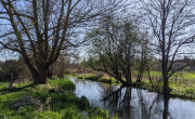
The River Kennet is one of England's most important chalk streams. Some 45 miles long, it is the largest tributary of the Thames and in summer months contributes up to half its flow.
It runs through the North Wessex Downs Area of Outstanding Beauty and passes by some of Britain's most important prehistoric sites, including the World Heritage Site of stone circles and avenue at Avebury and Silbury Hill, before flowing through Marlborough, Hungerford, Newbury and Reading, where it joins the River Thames. The Kennet has numerous tributaries including the rivers Lambourn (a Site of Special Scientific Interest and a Special Area of Conservation), Enborne, Og and Foudry Brook.
The Pang is also a chalk stream. It is 14 miles long and rises in the west of Berkshire, from its source near the village of Compton flowing to its confluence with the Thames in the village of Pangbourne.

For more easy ways to support us click here